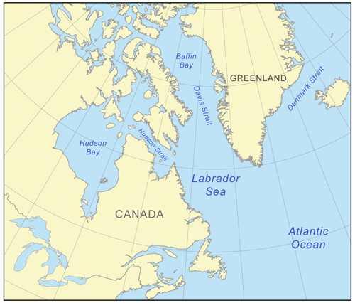
戴维斯海峡(Davis Strait),是巴芬岛和格陵兰岛之间的海峡,南接拉布拉多海,北连巴芬湾,南北全长约650公里,东西宽约325公里―450公里,平均水深2000米左右,是西北航道的一部分。
精选百科
本文由作者推荐
戴维斯海峡
巴芬岛和格陵兰岛之间的海峡
中文名
戴维斯海峡
外文名
Davis Strait
宽度
450米
长度
650米
平均深度
2000米
连接陆地
南接拉布拉多海,北连巴芬湾
海洋
大西洋和太平洋
得名

戴维斯海峡
该海峡得名于英国探险家约翰·戴维斯,他于1585年发现了这条海峡。海峡地理位置
中文
西格陵兰戴维斯海峡上的荷尔斯泰因斯堡
北大西洋海峡。位于巴芬岛(Baffin Island)东南部和格陵兰(Greenland)西南部之间,将巴芬湾(Baffin Bay)和拉布拉多海(Labrador Sea)隔开,形成穿越加拿大北极群岛沟通大西洋和太平洋的西北航道(Northwest Passage)的一部分。位于巴芬岛(BaffinIsland)东南部和格陵兰(Greenland)西南部之间,将巴芬湾(BaffinBay)和拉布拉多海(LabradorSea)隔开,形成穿越加拿大北极群岛沟通大西洋和太平洋的西北航道(NorthwestPassage)的一部分。南北长约400哩(650公里),东西宽约200哩―400哩(325公里―650公里)。南北长约400哩(650公里),东西宽约200哩―400哩(325公里―650公里)。西格陵兰洋流(Greenland Current)的较暖海水沿格陵兰岸北流,拉布拉多寒流(Labrador Current)则挟带大量冰块沿巴芬岛东岸南流注入拉布拉多海和大西洋。西格陵兰洋流(GreenlandCurrent)的较暖海水沿格陵兰岸北流,拉布拉多寒流(LabradorCurrent)则挟带大量冰块沿巴芬岛东岸南流注入拉布拉多海和大西洋。格陵兰主要港口(包括腓特烈斯霍布〔Frederikshab〕、戈特霍布〔Godthab〕和荷尔斯泰因斯堡〔Holsteinsborg〕)通航季节自仲夏延至秋末,但每年变化很大。海峡于1585年为探险家约翰·戴维斯所发现,因之得名。
ENGLISHDavisStrait , northern Atlantic Ocean. Lying between southeastern Baffin Island and southwestern Greenland, it separates Baffin Bay to the north from the Labrador Sea to the south, and forms part of the Northwest Passage. About 400mi(650km) north to south and 200mi―400mi(325km―650 km) wide, it was explored in 1585 by the English navigator John Davis. Along the coast of Greenland, the Greenland Current carries relatively warm water northward, while the cold Labrador Current transports icebergs southward along Baffin Island's eastern shore.Strait,northernAtlanticOcean.LyingbetweensoutheasternBaffinIslandandsouthwesternGreenland,itseparatesBaffinBaytothenorthfromtheLabradorSeatothesouth,andformspartoftheNorthwestPassage.About400mi(650km)northtosouthand200mi―400mi(325km―650km)wide,itwasexploredin1585bytheEnglishnavigatorJohnDavis.AlongthecoastofGreenland,theGreenlandCurrentcarriesrelativelywarmwaternorthward,whilethecoldLabradorCurrenttransportsicebergssouthwardalongBaffinIsland'seasternshore.
戴维斯海峡相关的文章

智能障碍是一组临床综合征,可有记忆、认知(概括、计算、判断等)、语言、视空间功能和人格等至少3项受损。智能障碍常由神经系统疾病、精神疾病和躯体疾病引起。智能障碍的主要症状包括记忆障碍、认知与判断障碍、人格改变、情感障碍。智能障碍的治疗主要是针对脑部原发病的治疗及康复治疗。智能障碍给患者的正常生活、学
林朝英是金庸武侠小说《神雕侠侣》中的虚构人物,古墓派的开山祖师。她是小龙女的师祖,杨过的太师祖。林朝英的武功被认为是武林中最高的,超越了东邪、西毒、南帝和北丐等四大宗师。尽管她是一位女性,但由于不争名利,所以并没有很大的声望。林朝英与全真教的开山祖师王重阳是一对冤家情侣。她的容貌极美,但眼角间隐含着
十字军(The Crusaders),由天主教士兵组成的军队,曾参加十字军东征,士兵都佩有十字标志,因此称为十字军。十字军东征的目的是保护朝圣者和反对吉哈德扩张,以及从伊斯兰诸国手中拯救半奴隶与奴隶并缓解突厥人对君士坦丁堡的压力。在十字军的帮助下,拜占庭帝国成功收复尼西亚、吕底亚、密细亚、弗里吉亚北

尚可名片
这家伙太懒了,什么都没写!
作者